
Whitehaven Beach Weather: Forecast, Seasons and What to Expect
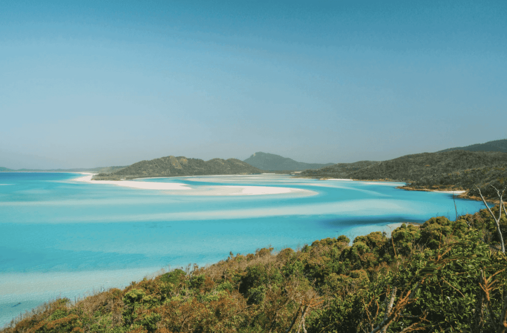
A trip to Whitehaven Beach is one of those Whitsundays experiences that looks effortless in photos: brilliant silica sand, turquoise shallows and sweeping archipelago views. In practice, the quality of your visit can be shaped by weather, wind, tide, cloud cover and marine conditions, so a little planning can make a big difference.
This famous stretch of sand lies on Whitsunday Island in Queensland and runs for about seven kilometres. Tourism Queensland notes that the sand is about 98 per cent silica, while the wider area forms part of the Great Barrier Reef region. The destination is accessible by boat and tour services rather than by road, which makes checking conditions before departure especially useful.
The good news is that this is a year-round destination. Some months are drier, some are hotter, and some bring a greater chance of tropical rain, but there is no single month that guarantees perfect conditions. The smarter approach is to understand the seasonal pattern, then check reliable information close to your travel date.
How to Read the Weather Forecast Before You Go
When you are planning an offshore trip, do not focus on one icon alone. A cloud symbol or small shower percentage tells only part of the story. Look at the expected temperature, wind strength, rainfall range and any marine warning before deciding what the day is likely to feel like.
The Bureau of Meteorology is the most useful starting point for official information in Australia. Its regional page combines nearby observations and short range information, while marine services cover waters along the Mackay coast from Bowen south to St Lawrence. Because the beach is offshore, conditions can differ from those on the mainland.
That difference matters. The gateway town may have cloud sitting over nearby ranges while the islands are brighter, or the reverse can happen. Local operators also watch changing conditions because boat comfort, visibility and access can be affected by wind and sea state.
For a trip later in the week, check the regional outlook first. Then review the details again the afternoon before departure and once more in the morning. An update close to travel is more useful than relying on a screenshot saved several days earlier.
Whitsundays Weather Across the Seasons
Historical Bureau of Meteorology data from nearby Hamilton Island gives a useful regional guide to temperature and rainfall patterns. It is not a measurement taken directly on the sand, so it should be treated as context rather than a guarantee for one exact location.
| Season | Typical regional pattern | Nearby station climate guide |
|---|---|---|
| Summer, December to February | Hotter, more humid and wetter, with a greater chance of tropical rain or a passing shower | Mean maximums around 30.0 to 30.4°C; monthly rainfall averages are highest in this period |
| Autumn, March to May | Gradual easing of heat and humidity, with rainfall generally reducing as the season progresses | Mean maximums fall from about 28.8°C in March to 24.8°C in May |
| Winter, June to August | Mild, drier conditions with cooler mornings and generally lower rainfall | Mean maximums are about 21.9 to 22.9°C, with August historically one of the drier months |
| Spring, September to November | Increasing warmth with many clear days before the wetter summer pattern returns | Mean maximums rise from about 25.4°C in September to 29.1°C in November |
The data also shows why the late dry season and spring are popular with travellers seeking a milder beach visit. September has historically recorded relatively low average rainfall at the station, while averages for clear conditions are also higher through parts of the cooler season. Still, long term averages describe a broad pattern, not what will happen on one particular date.
Temperature, Sun and What It Feels Like on the Sand
The air temperature is only one part of comfort. Direct sun, humidity and reflected light from pale sand can make the beach feel brighter and hotter than the number on a phone screen suggests. Even in mild conditions, UV protection matters.
In summer, daytime conditions can feel warm and humid, especially when cloud clears after an early shower. During the cooler months, the air can be much more comfortable for walking, sightseeing and spending longer periods outside. A light layer can still be useful on the boat, particularly if you leave early or return near night.
The white silica sand is one of the reasons the destination is so distinctive, but the brightness also means sunglasses and a hat are worth packing. If your itinerary includes the Hill Inlet viewing area, the walk adds some exposure, so allow for shade breaks where available and carry drinking water.
Wind, Marine Conditions and Beach Weather
For boat travellers, wind often matters as much as whether conditions look blue and clear. Stronger wind can create a bumpier ride, increase spray and change how comfortable exposed sections of the trip feel. Light winds can make the journey gentler, although actual comfort also depends on direction, swell and the vessel being used. One condition worth watching is whether the breeze is expected to strengthen during your time offshore.
Do not assume that a sunny icon means completely calm conditions. A sunny spell can still have noticeable wind, while an overcast period may arrive with relatively smooth seas. This is why marine information deserves a separate look from the general land based display.
The Mackay coastal waters information is particularly relevant because it covers the broader marine stretch in the region. If you are prone to motion sickness, follow the advice provided by your tour operator and prepare before departure rather than waiting until the boat is already moving. The Bureau provides separate marine information covering wind, swell and expected conditions for these waters.
Rain, Shower Chance and Tropical Changes
Rain in this tropical part of the country does not always mean an entire visit is lost. During wetter months, a shower can pass quickly, and conditions may brighten again afterwards. At other times, a broader system can produce persistent cloud, heavier falls or rougher marine conditions.
Pay attention to the chance of precipitation and the expected rainfall amount together. A relatively high percentage does not tell you how long a shower might last or how much may fall. Timing matters too. A higher afternoon chance may have little impact on an early visit, while an overnight system may leave unsettled conditions into the next morning.
Local geography also creates variation. Clouds can gather over nearby ranges close to shore while offshore areas stay brighter. That is one reason regional conditions should be checked as a broader picture rather than judged only by what you can see from your accommodation.
Local tourism guidance similarly notes that cloud and rainfall around the ranges near the gateway can differ from conditions across the passage and surrounding islands.
Current Conditions and What to Check Today
On the morning of your tour, review the latest readings before leaving. Start with the Bureau of Meteorology, then compare nearby observation stations when useful. A weather radar image can help show approaching rain, while satellite imagery gives a broader view of cloud across the region.
An hourly weather view can also be useful when timing is important. Rather than asking whether precipitation will occur at all, look at how conditions may change from one hour to the next. If official alerts are issued, follow official advice and the instructions from your operator.
A weather map is most useful when read alongside real observations. The screen may show a broad system, but local stations can reveal what is actually happening nearby. For visitors, the goal is not to become a meteorologist before breakfast. It is simply to combine a few reliable signals instead of betting the entire trip on one app.
Is There a Best Time to Visit?
There is no universal best month because different travellers want different things. Tourism Whitsundays describes April to October as generally milder with lower humidity, while November to March is warmer and wetter. Marine stingers can be present in every season, with a higher risk from November to May, so protective clothing and crew guidance are important when entering the ocean.
If your priority is walking, photography and lower humidity, the cooler months can be appealing. If you enjoy tropical warmth and do not mind a greater chance of passing showers, the warmer months can still deliver spectacular offshore visits.
The cooler season is particularly comfortable for many visitors because it sits in the drier, milder part of the climate cycle, although no month is immune to changing conditions. The most useful strategy is to choose dates that suit your travel style, then make final decisions using official information close to departure.
Planning a Day Trip from Airlie Beach
Most visitors reach the beach by joining a guided tour from the regional hub or another resort base. That means your planning should consider both the destination and the journey across open stretches of ocean.
Red Cat Adventures offers the Thundercat All-Inclusive Day Tour, which visits the beach, Hill Inlet lookout and includes two snorkelling opportunities on fringing reef sites. The company describes Thundercat as designed for stability and speed, which can be reassuring for travellers who are concerned about seasickness.
Before booking, check the latest tour inclusions, age requirements, departure details and what equipment is supplied. Conditions and itineraries can change, so the operator instructions for your chosen date take priority over general travel advice.
It is also worth building some flexibility into a longer holiday. If you are staying for several days, avoid treating one exact date as your only possible opportunity when your schedule allows alternatives. A little flexibility can help if operators need to adjust plans because of marine conditions.
What to Pack for Changing Conditions
A sensible small bag should cover spray, changing conditions and an unexpected wet spell without becoming bulky. Bring a hat, sunglasses, broad spectrum sunscreen, swimwear, a towel and a refillable bottle. A lightweight long sleeved layer can help with UV exposure and can also feel useful during a breezier return trip.
For swimming or snorkelling, follow the protective clothing guidance from your operator. Regional tourism guidance advises that marine stingers may be present in every season, with higher risk from November to May. Many tours provide or recommend full body Lycra suits during higher risk periods, so confirm what is included before you arrive.
Footwear also depends on your itinerary. If a walking track is included, choose something secure enough for the path rather than relying only on loose beach footwear. Keep electronics in a dry bag or protected case because spray can appear even when the conditions look calm.
Why Offshore Conditions Can Look Different
One of the easiest mistakes is judging an offshore trip entirely from the view in town. The region covers islands, channels, ranges and open ocean, all of which can experience slightly different cloud, breeze and rainfall at the same time.
Local tourism guidance notes that cloud can settle over the Conway ranges behind the gateway town while conditions in the passage between the islands and around the islands are brighter. That does not mean you should ignore what you see outside your hotel. It means local conditions need context.
This is also why tour crews are useful sources of practical advice. They travel the region regularly and make decisions using official information, marine conditions and direct experience on the route. If you are uncertain, ask what the expected ride and activity conditions are likely to be rather than asking only whether conditions will be sunny.
Final Planning Advice
The perfect visit is not defined by a completely cloudless sky. A mix of bright periods, light cloud and comfortable breezes can still produce beautiful views, excellent swimming and memorable photos. What matters more is understanding whether conditions are safe, comfortable and suitable for the activities you have planned.
Use official sources for current information, pay attention to wind and marine conditions, and recheck details close to departure. Treat long range climate information as a planning guide rather than a promise. Conditions in tropical marine regions can change, and the most reliable decision is the one based on the latest information available.
When you are ready to turn the planning into an actual trip through the islands, Red Cat Adventures offers tours that combine the region’s signature scenery with guided access to major highlights. Check current availability, confirm what is included, and choose the experience that fits your pace.
A little preparation goes a long way. Once the practical details are covered, you can spend less time staring at apps and more time enjoying one of the country’s most remarkable archipelago landscapes.